Stephens Creek: Difference between revisions
mNo edit summary |
|||
| (11 intermediate revisions by the same user not shown) | |||
| Line 1: | Line 1: | ||
== Recent Updates == | == Recent Updates == | ||
'''There's an upcoming land-tending event | |||
=== '''There's an upcoming land-tending event every second Saturday from 10 a.m.-12:30 p.m.''' === | |||
The nearest address is 7730 SW 4th Ave. in Portland, OR, and we will be meeting at the top of the stairs. Please bring shovel, clippers, watertight shoes, and gloves if you have them! | |||
For more information about past events and how they went, please [[Stephens Creek Updates|visit here.]] | For more information about past events and how they went, please [[Stephens Creek Updates|visit here.]] | ||
== Short Documentary on the Project by Danielle Hinz == | |||
[[File:Restoring a Roadside Landscape (1).png|left|thumb]] | |||
A local community group has adopted a ten-acre stretch of Oregon State land (owned by the Oregon Department of Transportation) through the Adopt-a-Highway program. We are calling this area under I-5 Fringecup Landing as there are native fringecup plants in the area. | |||
Existing in a riparian zone along Stephens Creek, a significant tributary to the Willamette River, Fringecup Landing represents a key restoration opportunity for the health of beavers and salmon in the area. | |||
[https://youtu.be/DI_GQ4VbxlM Click here] to watch a three-minute documentary about the project. | |||
== Interactive Map == | |||
If you'd like to play with an interactive map of the project and the surrounding area, [https://www.google.com/maps/d/u/0/edit?hl=en&mid=16KXgJnVJzGzSoXBUTu5vFqoXSnRegYs&ll=45.469670154534995%2C-122.68482992207562&z=18 click here.] | |||
== Background == | == Background == | ||
[[File:20250124 135834.jpg|thumb|Stephens Creek, Willamette River Watershed, "Portland, OR"]] | [[File:20250124 135834.jpg|thumb|Stephens Creek, Willamette River Watershed, "Portland, OR"]] | ||
[https://youtu.be/boaKUd9MubU?si=bykVz2VHuGCQakN3 Here's a longer video about this project and how it came to be.] | |||
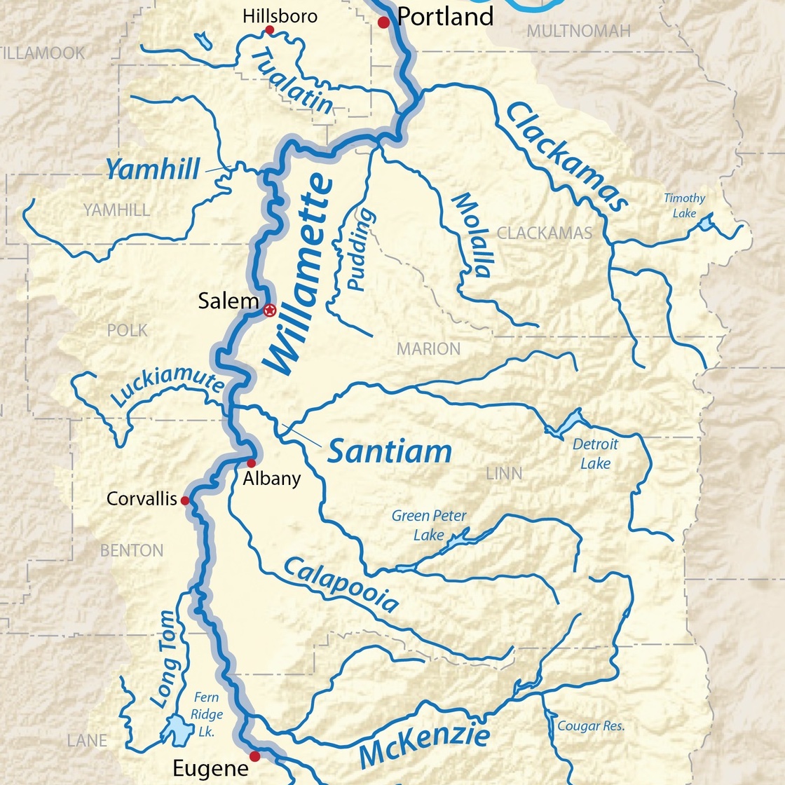
Stephens Creek is a tributary that flows year-round toward the [[Willamette River]]. The headwaters begin up near the [https://www.oregonjcc.org/ Mittleman Jewish Community Center.] The creek then flows down through the [https://www.portland.gov/parks/stephens-creek-nature-park Stephens Creek Nature Park], through an Oregon Department of Transportation (ODOT) riparian area, through land "owned" by Portland Metro, and then down toward the Willamette River. | Stephens Creek is a tributary that flows year-round toward the [[Willamette River]]. The headwaters begin up near the [https://www.oregonjcc.org/ Mittleman Jewish Community Center.] The creek then flows down through the [https://www.portland.gov/parks/stephens-creek-nature-park Stephens Creek Nature Park], through an Oregon Department of Transportation (ODOT) riparian area, through land "owned" by Portland Metro, and then down toward the Willamette River. | ||
| Line 13: | Line 28: | ||
==== Water Health & Safety ==== | ==== Water Health & Safety ==== | ||
There are 5+ stormwater drains that run directly into the creek in this ODOT area. These pipes transfer run-off from the street, which is known to include microplastics, heavy metals, and automotive chemicals from the street. No water testing has been done yet. If you would like to help us with water testing, please contact ''' | There are 5+ stormwater drains that run directly into the creek in this ODOT area. These pipes transfer run-off from the street, which is known to include microplastics, heavy metals, and automotive chemicals from the street. No water testing has been done yet. If you would like to help us with water testing, please contact '''avltavin@gmail.com.''' | ||
Additionally, there are several drainage holes that pour water directly from the freeway on-ramp down onto the walking path. | Additionally, there are several drainage holes that pour water directly from the freeway on-ramp down onto the walking path. | ||
| Line 44: | Line 59: | ||
Unfortunately, there is not a lot of information available online on how to adopt a landscape or which landscapes are available through ODOT (Oregon Department of Transportation). The best thing to do is to reach out to '''d2bup@odot.oregon.gov''' and ask. You can also go to [https://www.portlandmaps.com/ Portland Maps] to get information about which public entity might own the land you want to work on. | Unfortunately, there is not a lot of information available online on how to adopt a landscape or which landscapes are available through ODOT (Oregon Department of Transportation). The best thing to do is to reach out to '''d2bup@odot.oregon.gov''' and ask. You can also go to [https://www.portlandmaps.com/ Portland Maps] to get information about which public entity might own the land you want to work on. | ||
For the Stephens Creek riparian area, we worked with ODOT to adopt the landscape. The worksite is technically listed as being associated with the land to the right of Northbound I-5 between mile marker 4.34 and 4. | For the Stephens Creek riparian area, we worked with ODOT to adopt the landscape. The worksite is technically listed as being associated with the land to the right of Northbound I-5 and OR99-W between mile marker 4.34 and 4.76, under the Terwilliger on-ramp. | ||
Per the agreement with ODOT, [[Northern Willamette Valley|Regenerate Northern Willamette Valley]] must pickup trash in the area at least four times per year and pull invasive species at least twice per year. Currently, we plan to offer a land-tending gathering to the community once per month, typically on the last Saturday of the month from 10 a.m.-12:30 p.m. See our [[Stephens Creek Work Tracker|work tracker]], or contact ''' | Per the agreement with ODOT, [[Northern Willamette Valley|Regenerate Northern Willamette Valley]] must pickup trash in the area at least four times per year and pull invasive species at least twice per year. Currently, we plan to offer a land-tending gathering to the community once per month, typically on the last Saturday of the month from 10 a.m.-12:30 p.m. See our [[Stephens Creek Work Tracker|work tracker]], or contact '''avltavin@gmail.com''' for more information. | ||
== Partnerships == | == Partnerships == | ||
Latest revision as of 19:43, 2 March 2026
Recent Updates
There's an upcoming land-tending event every second Saturday from 10 a.m.-12:30 p.m.
The nearest address is 7730 SW 4th Ave. in Portland, OR, and we will be meeting at the top of the stairs. Please bring shovel, clippers, watertight shoes, and gloves if you have them!
For more information about past events and how they went, please visit here.
Short Documentary on the Project by Danielle Hinz
.png)
A local community group has adopted a ten-acre stretch of Oregon State land (owned by the Oregon Department of Transportation) through the Adopt-a-Highway program. We are calling this area under I-5 Fringecup Landing as there are native fringecup plants in the area.
Existing in a riparian zone along Stephens Creek, a significant tributary to the Willamette River, Fringecup Landing represents a key restoration opportunity for the health of beavers and salmon in the area.
Click here to watch a three-minute documentary about the project.
Interactive Map
If you'd like to play with an interactive map of the project and the surrounding area, click here.
Background

Here's a longer video about this project and how it came to be.
Stephens Creek is a tributary that flows year-round toward the Willamette River. The headwaters begin up near the Mittleman Jewish Community Center. The creek then flows down through the Stephens Creek Nature Park, through an Oregon Department of Transportation (ODOT) riparian area, through land "owned" by Portland Metro, and then down toward the Willamette River.
Additionally, a local neighbor, John Miller, has written this lovely blog about the bridges over Stephens Creek. Check it out!
Ecological Composition & Conservation Value
Water Health & Safety
There are 5+ stormwater drains that run directly into the creek in this ODOT area. These pipes transfer run-off from the street, which is known to include microplastics, heavy metals, and automotive chemicals from the street. No water testing has been done yet. If you would like to help us with water testing, please contact avltavin@gmail.com.
Additionally, there are several drainage holes that pour water directly from the freeway on-ramp down onto the walking path.
Animal Activity
Most importantly, there are active signs that this section of Stephens Creek is a beaver habitat. There are many downed trees in the area with many small dams. Mallard ducks also occasionally make their way up to this section of the creek.
From the Portland.gov website: "The Stephens Creek confluence, where Stephens Creek joins the Willamette River, has been found to be the most salmonid species-rich place in the city. This is the only stream reach in the city where the four most common salmon or trout species have been observed (chinook, coho, cutthroat and rainbow/steelhead trout)."
Native Shrubs
This area contains snowberry, oso berry, salmonberry, cleaver, red osier dogwood, maidenhair ferns, and nettle plants.
Native Trees
There are cedars, douglas firs, and maples naturally occurring in this area.
Invasive Plants
The area is dominated by Himalayan blackberry and English ivy. There are also smaller populations of ragweed, mullein (medicinal, but non-native), and teasel.
Future Planting Plan
Through ODOT, we are approved to plant red alder, white alder, Oregon white oak, western red cedar, vine maples, serviceberry, salal berry, flowering red currant, tall Oregon grape, cattail, and bearberry honeysuckle. We plan to work with local plant nursery co-ops such as SymbiOp to collect these plants and put them in the ground in Fall 2025. Additionally, we plan to propagate the native shrubs listed to improve diversity in the area and overtake the invasive plants. We hope to have success seeding some native grasses that thrive in shady environments.
Neighborhood Value
This section of Stephens Creek is followed by an ODOT access road (gravel/dirt) that comes in from Custer St. Later, this section was adapted as part of SW Trails #4. There is a bench along the stairs down to the area and a small amount of creek access at the end of the ODOT fence (near Custer St.). Many neighbors live along the top of the riparian area and are invested in the space.
Additionally, as the area is close to Trimet Bus Line #12, there is a fair amount of foot traffic. This is also a good route from SW 4th Ave. toward Fulton Community Garden. There are occasionally houseless neighbors who seek shelter from the elements in this location, and we do everything we can to be respectful of their space while tending the land.
Many neighbors also bring compost and leaf material to this location to nourish the soil when they have a surplus.
ODOT Adopt-a-Landscape Program
Unfortunately, there is not a lot of information available online on how to adopt a landscape or which landscapes are available through ODOT (Oregon Department of Transportation). The best thing to do is to reach out to d2bup@odot.oregon.gov and ask. You can also go to Portland Maps to get information about which public entity might own the land you want to work on.
For the Stephens Creek riparian area, we worked with ODOT to adopt the landscape. The worksite is technically listed as being associated with the land to the right of Northbound I-5 and OR99-W between mile marker 4.34 and 4.76, under the Terwilliger on-ramp.
Per the agreement with ODOT, Regenerate Northern Willamette Valley must pickup trash in the area at least four times per year and pull invasive species at least twice per year. Currently, we plan to offer a land-tending gathering to the community once per month, typically on the last Saturday of the month from 10 a.m.-12:30 p.m. See our work tracker, or contact avltavin@gmail.com for more information.
Partnerships
We are currently in partnership with Westside Watersheds, a City-funded community resource to help small landscape groups develop stormwater gardens and do watershed cleanups. They have allowed us to borrow tools and have given us a stipend to purchase native plants from local plant nursery co-ops.
Additionally, we are supported by the South Burlingame Neighborhood Association and the South Burlingame Neighborhood Emergency Team (SBNET), who have both supplied volunteer labor. Some community members from the mutual aid group, Community Unconditionally Taking care of Each other (C.U.T.E.), have supported this project and outreach to houseless neighbors.
We are currently in the process of applying for grants through the Portland Clean Energy Fund as well as the Portland Parks Foundation.